
Transformation Through Time
Valley Wilds article written by Ranger Jay Manning.
When traveling through the Bay Area, one of the first things you notice is the numerous hills in the surrounding landscape turning into scenic coastlines as you approach San Francisco. The Bay Area has not always been this way.
The familiar hills in the Bay Area are new geologically speaking. San Francisco Bay, as we know it today, formed about 10,000 years ago due to hundreds of thousands of years of large tectonic plates colliding and sliding past each other, the rise and fall of sea level, and melting glaciers.
The Former Land

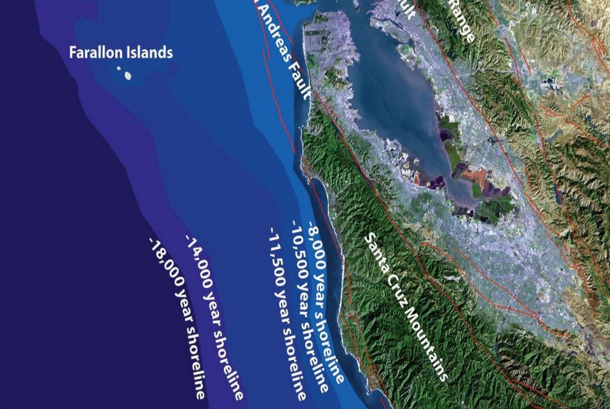
Approximately 700,000 years ago, large amounts of water were held within glaciers in the Sierra Nevada and upper third of North America. Due to the glaciers, the sea level was about 400 feet lower than it is today, and the California coastline was 27 miles west of its current location. The Farallon Islands, which can sometimes be viewed from San Francisco were part of the valley that became what we now know as the San Francisco Bay.
What Do Ice Ages Have to do With San Francisco Bay? (U.S. National Park Service) (nps.gov)
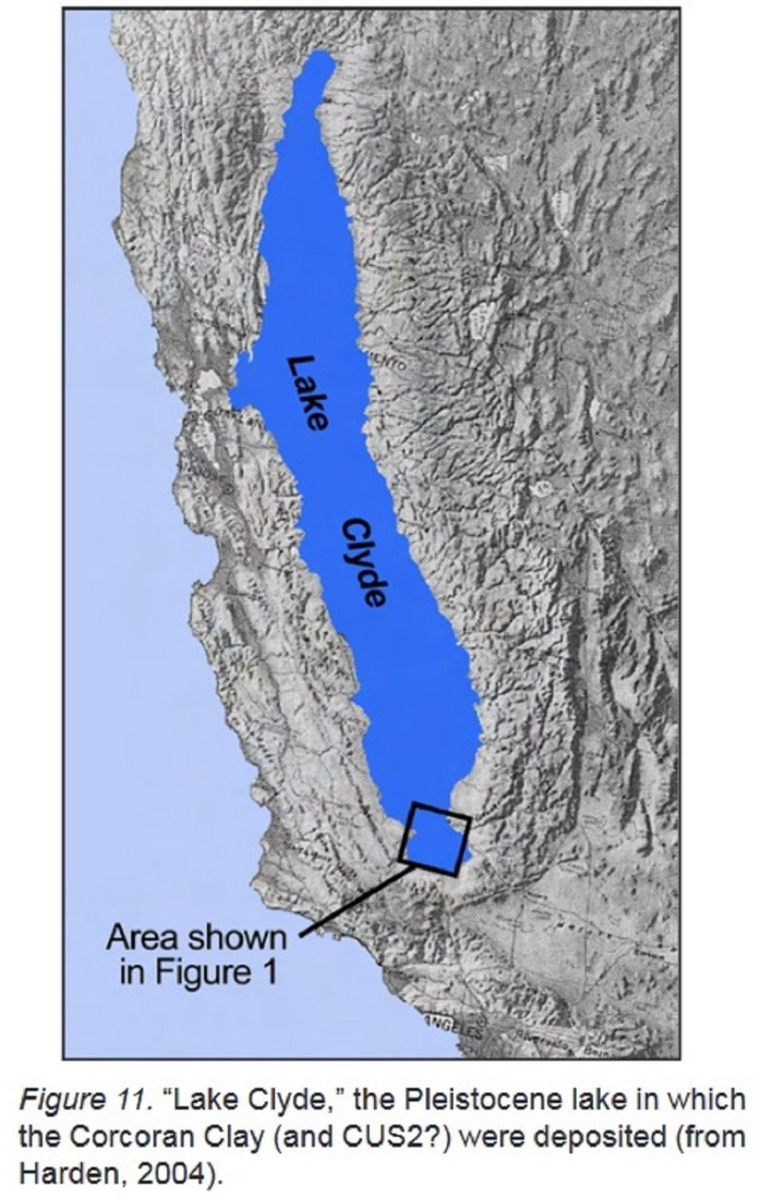
The valley was primarily covered in grasses and hedges, and a large river known as the “California River” cut through the valley. The “California River” flowed through the currentday Raccoon and Golden Gate Straits. Also , a massive glacier-fed lake, Lake Clyde, covered the currentday Central Valley. Around 650,000 years ago, the Earth began thawing, and flood waters began pooling in Lake Clyde, increasing the size of Lake Clyde close to the size of Lake Michigan. Initially, the water overflowing from the lake flowed out to the ocean at Monterey. However, 560,000 years ago, tectonic plates began shifting, causing the lake to overflow at the next lowest spot, much farther north. Flood waters broke through at speeds comparable to those at Niagara Falls. The catastrophic flood formed the currentday Carquinez Strait and started to carve out the Sacramento River Valley. Following the creation of the Carquinez Strait, Lake Clyde drained leaving, Kern, Buena Vista, and Tulare Lakes.
The Last Ice Age

The Last Ice Age began around 111,000 years ago.. When most people think of the Ice Age, they probably picture everything covered in ice and extremely cold temperatures; this was not the case in California. 111,000 years ago, California’s climate was like the current climate. California had wet winters and dry, hot summers. Annual precipitation may have been higher than present averages, but the overall climate was similar.
The temperate climate and lush valley lead to an abundance and diversity of wildlife in the Bay Area. Towards the end of the ice age, 15,000 years ago, this biodiversity was comparable to the Serengeti Plains of East Africa. Several grazing animals thrived in the valley. These herbivores included mammoths, mastodons, shrub ox, camels, horses, bison, llamas, elk, and tapirs. Among herds of these herbivores were predators such as the short-faced bear, saber-tooth cat, the dire wolf, mountain lions, and the American lion.
The Present
Clues about how the Bay Area was formed are still being studied and fossils are continuously being discovered. Many fossils have been and continue to be unearthed during construction projects in areas of the Bay. As more of these fossils are uncovered, it helps scientists' piece together what animals used to live in the area and routes they used to migrate or graze. A way scientists can identify migration or grazing routes is through “polishing,” a process in which boulders are smoothed due to herbivores such as mammoths or mastodons rubbing their tusks on the boulders as a grooming method. While these megafauna are long gone, many boulders along the Bay Area coast still show evidence of polishing.
The Future
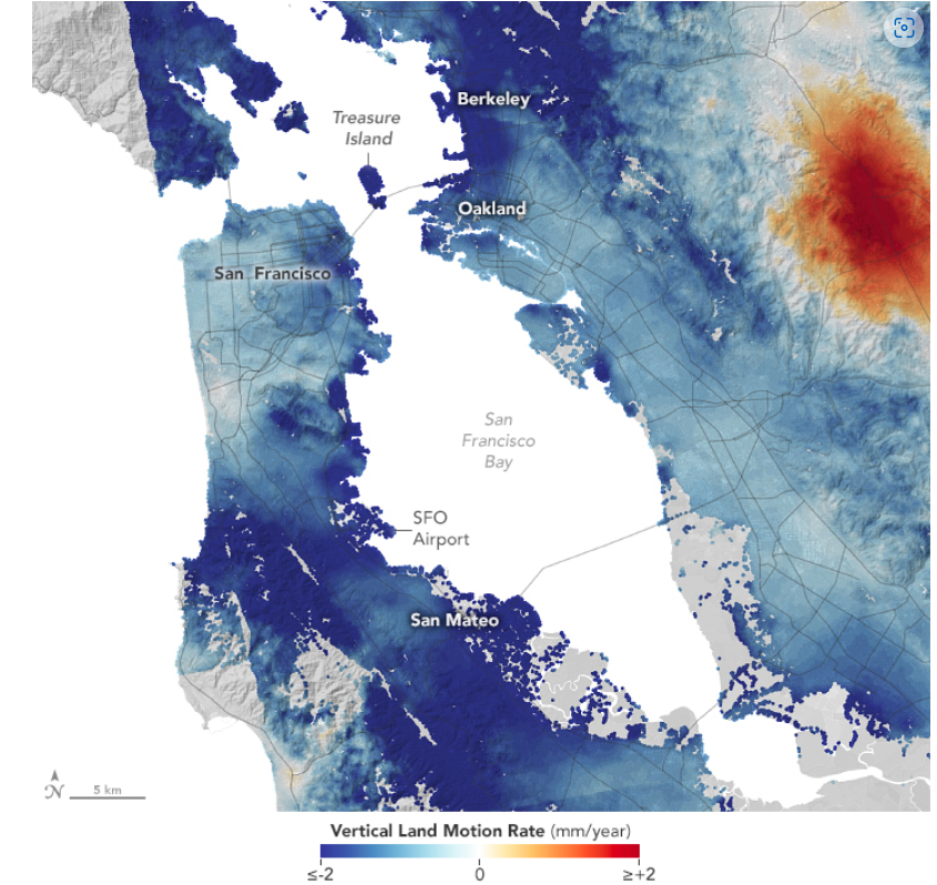
Change is not only just a thing of the past. Although it happens slowly, tectonic plates continue to move, shifting the land beneath us. Additionally, sea level is on the rise due to climate change. The combination of these two factors will change the Bay Area over time. Areas along the San Francisco Bay are sinking by approximately 2mm per year; this will exacerbate the impact of rising sea levels. According to 2018 predictions, sea levels in San Francisco are expected to rise by approximately 3 feet by 2100. As the land around us slowly changes, we must do our best as a community to transition to the changes in the most sustainable way possible.
Ranger Program at Sycamore Grove Park
Join Ranger Rudy for Megafauna in California nature program. He’ll have visual aids and will talk about the megafauna--the large animals from the Pleistocene Era. Come see how the animals from the past relate to today’s animals.
Saturday, February 22nd 11am – 12pm